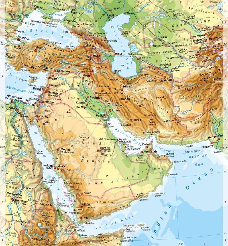
West Asia (Middle East) - Physical map
Physical map and the formation of Israel
978-3-14-100890-6 | Page 138 | Ill. 1
Overview
West Asia, also known as the Near or Middle East, is located in the southwestern part of the Asian continent. It includes the Asian part of Turkey (Anatolia with the Pontic Mountains and the Taurus), the Caucasus region, the Arabian Peninsula with its deserts (Arabian Desert, Nefud, Syrian Desert) including Mesopotamia, and the highlands of Iran with the Great Salt Lake Desert (Dasht e Kavir) and the Lut Desert. In the north, the Iranian Plateau are framed by the Elburz, in the west and south by the Zagros Mountains and in the northeast by the Kopet-Dag. In the east, the Afghan Highlands lead to the Hindu Kush.
Arid regions in West Asia
Decisive for the concentration of settlement on the coasts and along the major rivers are extensive deserts and arid areas in large parts of West Asia, with annual precipitation below 100 millimetres. The Arabian Peninsula, for example, is one of the largest desert areas on earth, it is uninhabitable over large areas and hardly accessible. In the Great Salt Lake Desert in Iran and the deserts of Afghanistan, the aridity is intensified by the surrounding mountains. The Karakum Desert in Turkmenistan has been crossed since the 1950s by the Karakum Canal, a Soviet Union hydraulic engineering project that is considered one of the main causes of the disappearance of the Aral Sea (see map 115.4).
As one of the most important cradles of civilisation - and the origin of the three world religions Judaism, Christianity, and Islam - West Asia has a striking accumulation of ruined sites, especially in the area of the Fertile Crescent from Egypt through Mesopotamia down to Persia.